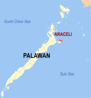
Araceli
Appearance
Page Module:Infobox/styles.css has no content.
| Araceli | |
|---|---|
| Baley na Filipinas | |
 Lokasyon na Araceli | |
 | |
| 10°33′10″N 119°59′25″E | |
| Dalin | Filipinas |
| Angipaletnegan | 1961 |
| Barangay | 13 |
| Kaawang | |
| • Katiponan | 204.30 km2 (78.88 sq mi) |
| Elebasyon | 11 m (36 ft) |
| Bilang na too (Mayo 1, 2020)[1] | |
| • Katiponan | 14,434 |
| • Densidad | 71/km2 (180/sq mi) |
| Economia | |
| • Clase | kumapat ya klase ya baley |
| • Ingresos | ₱46,039,611.7951,474,265.5958,488,657.4265,196,163.2771,495,040.8882,397,968.9088,101,128.6594,930,945.24113,586,046.06152,817,151.50 (2012) |
| • Activos | ₱38,005,535.5039,129,517.1852,135,050.6771,639,631.6675,487,662.08140,762,203.86195,441,742.15208,071,020.25271,211,528.17309,773,545.70 (2012) |
| • Pasivos | ₱24,488,941.4824,527,625.9132,201,246.0840,242,537.9334,969,817.6291,822,353.88136,519,427.08120,602,328.68141,016,146.44137,594,587.16 (2012) |
| • Gastos | ₱45,205,557.7749,890,631.7753,156,744.1052,232,297.6162,158,208.4075,285,409.6177,594,207.9478,512,460.7798,826,105.54120,002,514.75 (2012) |
| Kodigo na postal | 5311 |
| Kodigo na lugar | 48 |
Say Araceli et kumapat ya klase ya baley ed luyag na Palawan, Filipinas. Unong ed 1 Mayo 2020 census, say populasyon to et 14,434 totoo tan 3,505 abong. Walay kabaleg tan sukat to ya 204.30 sq. km. Say zip code to et 5311.
Saray barangay
[dumaen | dumaen so pinanlapuan]- Tinintinan
- Dalayawan
- San Jose De Oro
- Taloto
- Santo Niño
- Balogo
- Lumacad
- Mauringuen
- Maduldulon
- Osmeña
- Dagman
- Calandagan
- Poblacion
Demograpiko
[dumaen | dumaen so pinanlapuan]| Taon | Pop. | ±% p.a. |
|---|---|---|
| 1903 | 2,146 | — |
| 1960 | 4,955 | +1.48% |
| 1970 | 4,444 | −1.08% |
| 1975 | 5,552 | +4.57% |
| 1980 | 6,030 | +1.66% |
| 1990 | 8,708 | +3.74% |
| 1995 | 10,556 | +3.67% |
| 2000 | 10,894 | +0.68% |
| 2007 | 13,233 | +2.72% |
| 2010 | 14,113 | +2.37% |
| 2015 | 14,909 | +1.05% |
| 2020 | 14,434 | −0.63% |
| Reperensiya: Philippine Statistics Authority[2][3][4] | ||
Saray reperensiya
[dumaen | dumaen so pinanlapuan]- ↑ "2020 Census of Population and Housing (2020 CPH) Population Counts Declared Official by the President". Hulyo 7, 2021. https://psa.gov.ph/content/2020-census-population-and-housing-2020-cph-population-counts-declared-official-president.
- ↑ Census of Population (2015). "Region IV-B (Mimaropa)". Total Population by Province, City, Municipality and Barangay. PSA. Retrieved 29 June 2016.
- ↑ Census of Population and Housing (2010). "Region IV-B (Mimaropa)". Total Population by Province, City, Municipality and Barangay. NSO. Retrieved 29 June 2016.
- ↑ Censuses of Population (1903–2007). "Region IV-B (Mimaropa)". Table 1. Population Enumerated in Various Censuses by Province/Highly Urbanized City: 1903 to 2007. NSO.
Saray gawing ed labas
[dumaen | dumaen so pinanlapuan]