Taal (Batangas)
Utseende
| Taal | |||
|---|---|---|---|
 | |||
| Land | |||
| Status | kommune | ||
| Oppkalt etter | Taal (vulkan) | ||
| Postnummer | 4208 | ||
| Retningsnummer | 43 | ||
| Areal | 29,76 km² | ||
| Befolkning | 61 460[1] (2020) | ||
| Bef.tetthet | 2 065,19 innb./km² | ||
| Antall husholdninger | 14 977 | ||
| Språk | Tagalog | ||
| Høyde o.h. | 63 meter | ||
 Taal 13°53′00″N 120°56′00″Ø | |||

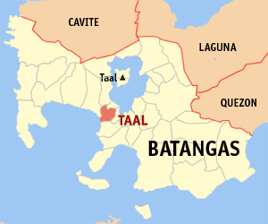
Taal (Bayan ng Taal) er en kommune på Filippinene. Kommunen ligger på øya Luzon og tilhører provinsen Batangas.
Taal er et tostavelsesord.
Til tross for sitt navn grenser ikke kommunen til Taal Lake og dermed heller ikke til vulkanen Taal, men den er uansett temmelig nær.
Barangayer
[rediger | rediger kilde]Taal er inndelt i 42 barangayer.[2]
|
|
|
Referanser
[rediger | rediger kilde]- ^ «2020 Census of Population and Housing (2020 CPH) Population Counts Declared Official by the President». folketellingen 2020. Filippinenes statistikkbyrå. 7. juli 2021.
- ^ Barangays in Taal (Batangas) 2018 Philippine Standard Geographic Code (PSGC)
Kilder
[rediger | rediger kilde]- 2015 Census of Population and Housing Report Philippine Statistics Authority