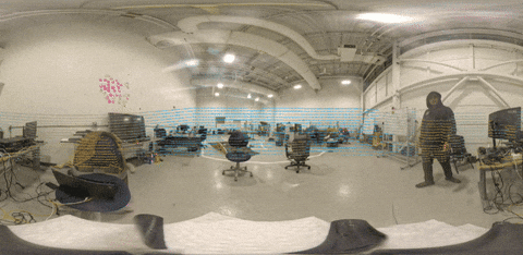
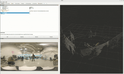
A ros 2 package designed for 360° camera and lidar fusion. it captures equirectangular video feeds and lidar point clouds, fusing them to create textured 3d representations of the environment. omnivision provides visualization feeds and 360° depth information with only 2 sensors.
Applications include anywhere you need full surrounding depth information using only 2 sensors. This idea was originally created for full coverage lane detection, but would love to see other use cases!
This project was created for WayneHacks 3 @ Wayne State University! See the DevPost submission here.
-
360° Camera and LiDAR Integration: Full environmental coverage from 3D LiDAR and 360° camera.
-
Data Fusion: Combine camera and LiDAR data to generate textured point clouds.
-
Depth Map Generation: Creates textured and grayscale depth maps.
-
Dynamic Visualization Compute: Only generates pointclouds / depthmaps when topics have subscribers.
-
ROS 2 (Humble or newer recommended)
-
Python 3.8+
-
OpenCV
-
PCL
-
NumPy
- Clone the repository into your ROS 2 workspace:
git clone git@github.com:BlaineKTMO/omnivision.git /path/to/ros2_ws/src/omnivisionInstall dependencies:
sudo apt install ros-<your_ros2_distro>-cv-bridge ros-<your_ros2_distro>-pcl-ros
pip install numpy opencv-python
Build the package:
cd /path/to/ros2_ws
colcon build --symlink-install
Source the workspace:
source /path/to/ros2_ws/install/setup.bashTo start the Omnivision system, use the provided launch file:
ros2 launch omnivision bringup.launch.pyCustomize the launch file with the following parameters:
-
camera_topic: Topic name for the 360-degree camera feed (default: /camera/image_raw).
-
lidar_topic: Topic name for the LiDAR point cloud data (default: /lidar/points).
-
output_topic: Topic name for the fused textured point cloud (default: /omnivision/fused_cloud).
-
depth_map_topic: Topic name for the generated depth map (default: /omnivision/depth_map).
To launch with custom topics:
ros2 launch omnivision bringup.launch.py camera_topic:=/my_camera lidar_topic:=/my_lidar-
Optimization: Improve processing efficiency and reduce resource usage.
-
LiDAR Interpolation: Add an option to interpolate LiDAR data for denser point clouds.
-
Launch File Configuration: Expand the launch file to support more customization options.
-
Documentation: Add additional details for usage or debugging.
-
Testing: Add unit tests.
-
Automatic localization: Capture camera transformation automatically.
This is a great project for new ROS2 developers to contribute to. Please create an issue prior to pull requesting to foster collaboration.
This project is licensed under the GNU GPL-3.0 License. See the LICENSE file for details.
For questions, suggestions, or collaboration opportunities, please open an issue on the repository or contact the maintainers directly.