Nandalur
This article needs additional citations for verification. (May 2011) |
Nandalur | |
|---|---|
 | |
 Dynamic map | |
| Coordinates: 14°15′00″N 79°07′00″E / 14.2500°N 79.1167°E | |
| Country | India |
| State | Andhra Pradesh |
| District | Annamayya |
| Talukas | Nandalur |
| Government | |
| • Type | Andhra Pradesh |
| Elevation | 151 m (495 ft) |
| Languages | |
| • Official | Telugu |
| Time zone | UTC+5:30 (IST) |
| PIN | 516150 |
| Telephone code | 08565 |
Nandalur is a town in Annamayya district of the Indian state of Andhra Pradesh. It is the headquarters of Nandalur mandal in Rajampeta revenue division.[1] The town is situated on the banks of the Cheyyeru River and has been an important religious and cultural hub for centuries.
Nandalur is on the west bank of river Cheyyeru. Once it was a famous Buddhist centre in Rayalaseema. In 1913 Buddhist caves and viharas were discovered.[2]
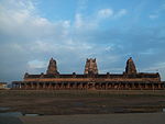
Sri Soumyanatha Swamy[3] is a temple situated nearly on ten acres of site. It is a replica of Thiruvannamalai Arunachalesvara Temple and patronized by Cholas, Pandyas, Kakatiyas, Vijayanagara, Pottapi and Matli Kings. Most of the inscriptions here are in Tamil. [4] Lord Sowmyanatha is installed on an elevated place.
History
[edit]Nandalur's history stretched back to the ancient Chola Empire and Vijayanagara Empire's. These empires played a role in shaping the cultural and architectural landscape of the region. Historical inscriptions found in and around Nandalur indicate that the town was an important center for religious activities, particularly during the medieval period.[citation needed]
Economy
[edit]The economy of Nandalur is predominantly based on agriculture.[5] The town is known for the cultivation of paddy, groundnut, sunflower, and various horticultural crops. Small-scale industries, such as textile weaving and pottery, also contribute to the local economy. Additionally, the town attracts religious tourists,[6] particularly to its temples, which supports the local economy through hospitality and related services.[citation needed]
Demographics
[edit]As per the 2011 Census of India, Nandalur has a population of approximately 25,000 people.[7] The literacy rate in Nandalur is higher than the national average, reflecting the community's emphasis on education. The population is primarily involved in agriculture, with a growing number of people working in trade, services, and small industries.
Sri Soumyanatha Swamy Temple (Nandalur)
[edit]The famous temple Sri Soumyanatha Swamy Temple (Nandalur) is a revered Hindu temple dedicated to Lord Vishnu, located in Nandalur Mandal of the Annamayya district, Andhra Pradesh, India.
Geography and climate
[edit]Nandalur is located at 14°15′00″N 79°07′00″E / 14.2500°N 79.1167°E.[8]
References
[edit]- ^ "Revenue Divisions and Mandals". Official website of YSR Kadapa District. National Informatics Centre- Kadapa, Andhra Pradesh. Archived from the original on 6 July 2015. Retrieved 23 May 2015.
- ^ "Nandalur | District YSR(Kadapa), Government of Andhra Pradesh | India".
- ^ "Sri Soumyanatha Swamy temple".
- ^ "Religious Tourism | District YSR(Kadapa), Government of Andhra Pradesh | India".
- ^ "Farmers gear up for Kharif season in Kadapa, Annamayya districts, nandalur".
- ^ Nandalur and near by temples attracts tourists
- ^ "As per the 2011 Census of India, Nandalur has a population of approximately 25,000 people".
- ^ Falling Rain Genomics.Nandalur
External links
[edit]


