Madeira
Appearance
Madeira | |
|---|---|
 A Januay 2014 view o Funchal, the caipital ceety o the autonomous region. | |
| Etymology: madeira, Portuguese for wid | |
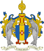
| Motto(s): Das Ilhas as Mais Belas e Livres (Scots: O aw islands, the maist beautifu an free) | |
 Location o Madeira relative tae Portugal (green) an the rest o the European Union (licht green) | |
| Coordinates: 32°45′N 17°00′W / 32.75°N 17°WCoordinates: 32°45′N 17°00′W / 32.75°N 17°W | |
| Kintra | |
| Autonomous Region | |
| Region | Atlantic Ocean |
| Subregion | Tore-Madeira Ridge |
| Poseetion | Madeira Platform, Savage Islands submarine munt |
| Settlement | c. 1420 |
| Admeenistrative autonomy | c. 1895 |
| Poleetical autonomy | 1 Julie 1976 |
| Caipital | Funchal |
| Municipalities | Calheta, Câmara de Lobos, Machico, Ponta do Sol, Porto Moniz, Porto Santo, Ribeira Brava, Santa Cruz, Santana, São Vicente |
| Govrenment | |
| • Preses (Govrenment) | Miguel Albuquerque |
| Area | |
| • Total | 741 km2 (286 sq mi) |
| Population (2016) | |
| • Total | 289,000 |
| • Density | 390/km2 (1,000/sq mi) |
| Time zone | UTC+0 (WET) |
| • Summer (DST) | UTC+1 (WEST) |
| Postal code | 9XXX-XXX |
| Area code(s) | (+351) 291 XXX XXX |
| HDI (2017) | 0.800[1] very high · 6th |
| Date format | dd-mm-yyyy |
| Drive | richt-side |
| Demonym | Madeiran; Madeirense |
| Patron Saunt | Nossa Senhora do Monte |
| Haliday | 1 Julie |
| Anthem |
|
| Currency | Euro (€)[2] |
| Website | www.madeira.gov.pt |
| Geografic detail frae CAOP (2010)[3] produced by Instituto Geográfico Português (IGP) | |
Madeira (/[unsupported input]məˈdɪərə/ mə-DEER-ə or /məˈdɛərə/ mə-DAIR-ə; Portuguese: [mɐˈðejɾɐ] or [mɐˈðɐjɾɐ]) is a wee Portuguese airchipelago that lees atween 32°22.3′N 16°16.5′W / 32.3717°N 16.2750°W an 33°7.8′N 17°16.65′W / 33.1300°N 17.27750°W, juist unner 400 km north o Tenerife, Canary Islands, in the north Atlantic Ocean an an ootermaist region o the European Union.[4] The airchipelago comprises the major pairt o ane o the twa Autonomous regions o Portugal (the ither being the Azores locatit tae the northwast), that includes the islands o Madeira, Porto Santo, an the Desertas, admeenistered thegither wi the separate airchipelago o the Savage Islands.
References
[eedit | eedit soorce]- Notes
- ↑ "Sub-national HDI - Area Database - Global Data Lab". hdi.globaldatalab.org (in Inglis). Retrieved 13 September 2018.
- ↑ Till 2002, the Portuguese escudo wis used in financial transactions, an till 1910 the Portuguese real wis the siller uised bi the monarchy f Portugal.
- ↑ IGP, ed. (2010), Carta Administrativa Oficial de Portugal (in Portuguese), Lisbon, Portugal: Instituto Geográfico Português, archived frae the original on 3 Julie 2014, retrieved 1 Julie 2011
- ↑ "EUROPA - Glossary - Outermost regions". Europa.eu. 17 Julie 2008. Retrieved 30 Julie 2010.

