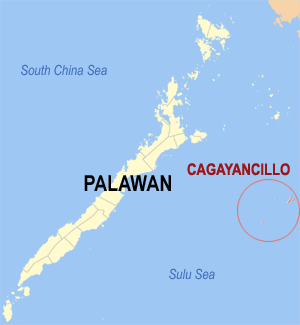
Cagayancillo
Ing Cagayancillo pang6 yang klasing balen king lalawigan ning Palawan, Filipinas. Agpang keng 1 Mayu 2020 ning sensus, atin yang populasyun a 6,884 a katau kareng 1,367 a pamimalemale.
Cagayancillo | |
|---|---|
 Mapa ning Palawan ampong Cagayancillo ilage | |
 | |
| Puuk: 9°34'36.8"N, 121°11'49.9"E | |
| Bansa | Filipinas |
| Labuad | Mimaropa (Rehiyong IV-B) |
| Lalawigan | Palawan |
| Tuknangan | Balen |
| Mitatag | 1810 |
| Barangay | 12 |
| Sukad | |
| • Kabilugan | 26.39 km2 (10.19 sq mi) |
| Elebasyun | 2 m (7 ft) |
| Populasyun (Sensu ning 1 Mayu 2020) | |
| • Kabilugan | 6,884 |
| • Densidad | 260/km2 (680/sq mi) |
| • Pamimalemale | 1,367 |
| Economia | |
| • Uryan | panganam yang klasing balen |
| • Panakitan | ₱24,810,430.3528,076,459.0131,397,132.842,893,423.2136,505,169.9943,233,214.1545,790,695.3249,947,265.3460,312,020.56 (2012) |
| • Activos | ₱21,595,216.5422,280,789.2628,049,827.8941,051,454.5569,573,285.1382,224,779.9091,119,648.65112,230,885.79120,235,041.35 (2012) |
| • Pasivos | ₱7,906,131.657,558,851.017,177,924.5710,936,136.8022,653,649.2124,699,933.8322,718,667.1438,899,771.3627,492,476.86 (2012) |
| • Gastos | ₱21,886,035.9322,590,484.8623,171,747.1427,172,698.2231,918,341.5032,608,918.9234,834,438.2640,906,167.0551,992,635.42 (2012) |
| Kodigo Postal | 5321 |
| PSGC | |
| IDD : area code | +63 (0)48 |
| Amanu | Kagayanen Palawano Tagálug |
Deng Barangay
mag-editIng Cagayancillo atin yang 12ng barangay.
- Bantayan (Pob.)
- Calsada (Pob.)
- Convento (Pob.)
- Lipot North (Pob.)
- Lipot South (Pob.)
- Magsaysay
- Mampio
- Nusa
- Santa Cruz
- Tacas (Pob.)
- Talaga
- Wahig (Pob.)
Demograpiku
mag-edit| Taun | Pop. | ±% p.a. |
|---|---|---|
| 1903 | 2,448 | — |
| 1918 | 3,198 | +1.80% |
| 1939 | 3,029 | −0.26% |
| 1948 | 4,167 | +3.61% |
| 1960 | 3,880 | −0.59% |
| 1970 | 3,598 | −0.75% |
| 1975 | 4,023 | +2.26% |
| 1980 | 3,992 | −0.15% |
| 1990 | 5,082 | +2.44% |
| 1995 | 6,717 | +5.37% |
| 2000 | 6,348 | −1.20% |
| 2007 | 6,506 | +0.34% |
| 2010 | 7,116 | +3.32% |
| 2015 | 6,285 | −2.34% |
| 2020 | 6,884 | +1.81% |
| Sanggunian: Philippine Statistics Authority[1][2][3][4] | ||
Panibatan
mag-edit- ↑ Census of Population (2015). "Total Population by Province, City, Municipality and Barangay". Total Population by Province, City, Municipality and Barangay. PSA.
- ↑ Census of Population and Housing (2010). "Total Population by Province, City, Municipality and Barangay". Total Population by Province, City, Municipality and Barangay. NSO.
- ↑ Censuses of Population (1903–2007). "Table 1. Population Enumerated in Various Censuses by Province/Highly Urbanized City: 1903 to 2007". Table 1. Population Enumerated in Various Censuses by Province/Highly Urbanized City: 1903 to 2007. NSO. https://archive.org/download/PhilippinesCensusofPopulationLGUs19032007/Region%204B%20Mimaropa%20Philippines%20Census%20of%20Population%201903%20-%202007.xls.
- ↑ Province of Palawan. Municipality Population Data. Local Water Utilities Administration Research Division. Retrieved on [[Disiembri 17, 2016]].